
Every June, the whole country looks skyward. Farmers ready their fields, city dwellers wait for relief from the scorching heat, and weather scientists track every twitch of the monsoon. This year, though, the script is reading differently. In the early days it looked as if the southwest monsoon would race across the country and drench it at record pace. Soon after it landed in Kerala, it swallowed up large swathes of southern and eastern India, and even the India Meteorological Department (IMD) seemed confident about its rapid spread. Then, almost overnight, it was as if someone yanked the handbrake.
Satellite images now show vast stretches of central, western and peninsular India stripped of clouds. Such a sight in mid-June is considered deeply unusual, and that is exactly what is keeping forecasters up at night. The big question: why did the monsoon stall halfway, and could it ripple out to farming, reservoirs and the wider economy in the days ahead?
Satellite Images Deepen the Concern
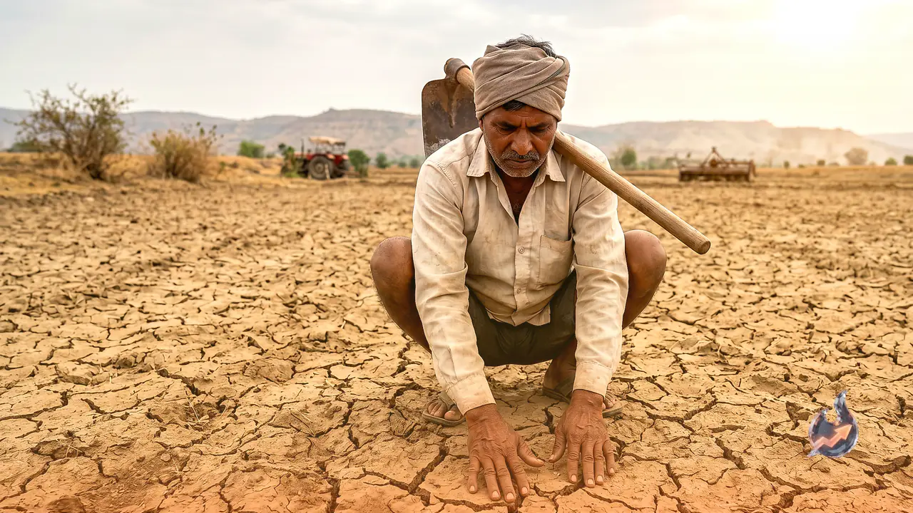
Fresh imagery from the European weather satellite Meteosat, the US agency NOAA and ISRO's INSAT-3DS has only sharpened the worry. Normally, in the second and third weeks of June, thick monsoon clouds blanket central India, Maharashtra, Madhya Pradesh and Chhattisgarh. This year the picture is the exact opposite. According to the department's figures, central India alone recorded a rainfall deficit of around 65 percent between June 4 and June 16, the highest of any meteorological region in the country. Several districts of Maharashtra, Madhya Pradesh and Chhattisgarh have not even received their normal monsoon showers.
This is precisely the window when sowing of kharif crops begins. So the monsoon's sluggish pace is no longer just a weather story, it ties directly into the livelihoods of crores of farmers and the nation's food security.
A Fast Start, Then a Sudden Halt
This year the southwest monsoon reached Kerala on June 4. It arrived three days later than the normal date, but the speed that followed surprised everyone. Within days it had covered Kerala, Tamil Nadu, Karnataka, Telangana, Andhra Pradesh, Goa, Odisha, West Bengal, Bihar and large parts of northeastern India. Scientists began to believe the monsoon might push into north and west India earlier than usual. But once the second week of June was over, its pace abruptly slowed and its advance came almost to a standstill in many areas.
In Maharashtra, the monsoon has been stuck around the Solapur region since after June 8. Vidarbha, which the monsoon usually reaches by June 15, is still waiting. In many parts of Uttar Pradesh too, the monsoon's arrival is now expected to be 5 to 10 days behind schedule. That is why the weather department is continuously reassessing the changing conditions.
The effects of this pause are already visible on the ground. Temperatures have started climbing again in several regions. Farmers have prepared their fields, but without adequate rain the sowing work is stalling. If the situation drags on, it could hit the very start of the kharif season.
Where Is the Monsoon Right Now
As things stand, the monsoon has already covered most of southern and eastern India, and the northeastern states are still seeing good rainfall. But across central, western and northwestern India its progress is falling short of expectations. Vidarbha, central Maharashtra, parts of Madhya Pradesh and many areas of north India are still waiting for monsoon rain. Lucknow usually sees the monsoon around June 23, but this time it is likely to arrive only in the last week of June or early July. Scientists believe that if favourable systems develop over the Bay of Bengal, the monsoon could turn active again in the second fortnight of June.
A Drought of Systems in the Bay of Bengal
The single biggest reason behind the slowdown is seen as the failure of strong low-pressure areas to form over the Bay of Bengal. Typically, one or two low-pressure systems develop in June. These are the systems that energise monsoon winds and carry moisture deep into the interior of the country. This year such systems have been all but absent, so the monsoon winds simply have not had enough energy to push forward. Experts say that until an effective system forms over the Bay of Bengal, the chances of the monsoon returning to its normal pace remain slim.
A Weak Trough and Western Disturbances
The monsoon trough is the belt of low pressure that fuels widespread rain across north and central India. This time that trough has stayed weaker than normal. A weak trough means the formation and spread of rain-bearing clouds will also remain limited. On top of that, western disturbances active over north India have interfered with the monsoon's normal advance. These weather systems have altered the wind patterns, leaving the monsoon currents unable to show their full strength.
El Niño's Return Adds to the Unease
The return of El Niño this year is another major source of worry for scientists. The IMD has already signalled that moderate to strong El Niño conditions could build up during the June to September monsoon season, something that could shape the overall behaviour of the weather.