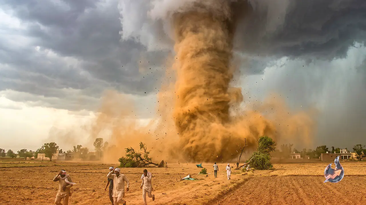

After two days of calm, the weather in Haryana turned violent again. On the afternoon of 15 June, the sky suddenly changed over Gurugram and several other parts of the state, bringing squalls and rain. The most startling sight came from the Siwani area of Bhiwani, where a wall of dust rose into a towering whirlwind roughly 100 metres high. In Hansi, light rain was accompanied by hail.
Which Districts Bore the Brunt
The storm swept across Hisar, Sirsa, Bhiwani, Rohtak, Narnaul, Rewari, Sonipat, Fatehabad and Panipat. In Gurugram the downpour was heavy enough to flood several roads and leave waterlogging in its wake. The India Meteorological Department (IMD) issued an alert for thunderstorms and rain across 15 districts of the state. The department says the swings in weather will continue in the days ahead, with the maximum temperature likely to climb by about 5 degrees over the next five days.
Storms May Return on 16 June
According to the weather office, Haryana faces the threat of heavy rain and strong storms again today, 16 June. In some areas wind speeds could touch 80-90 kmph. Winds this strong can uproot large trees and damage standing crops, which is why the department has urged ordinary residents, and farmers in particular, to stay extremely cautious. Many places will see partial cloud cover through the day, while the afternoon or evening could bring light to very light rain along with squalls, lightning, dust storms and winds of 40-50 kmph that may gust up to 60 kmph.
How to Stay Safe in the Storm
- Avoid standing under trees during the storm.
- Stay indoors when there is lightning.
- Do not lie down on concrete floors during lightning.
- Unplug electrical and electronic appliances.
- Keep following the weather department's updates and warnings.
- Farmers should protect their crops and livestock as far as possible.
Himachal's Weather for the Next Five Days
Neighbouring Himachal Pradesh is also seeing a shift in weather. Kangra, Mandi, Chamba, Kullu and Kinnaur are under a rain and storm alert between 16 and 18 June. According to the IMD, these areas could see winds of 60-65 kmph. The central and higher hill regions of the state are likely to remain under continuous cloud cover for the next five days, with intermittent light rain at some spots. The weather office has issued a yellow alert for Kangra, Kullu, Mandi and Shimla districts on 18 and 19 June, when these areas could face thunderstorms, gusty winds and lightning strikes, with wind speeds running between 30 and 40 kilometres per hour. On the remaining days the state will not face any major weather crisis.
Why the Monsoon Will Be Weaker This Time
The monsoon's mood in Himachal could be a little sluggish this year, with below-normal rainfall expected. The meteorological centre says the monsoon will be lighter than usual compared with previous years. A big reason is El Nino, which tends to reduce rainfall. Alongside it, the pressure pattern over the Indian Ocean is currently neutral. When this turns positive, the region gets good rain, but with it staying neutral this time, the monsoon is getting no extra push.
When Will the Monsoon Reach Himachal
The normal date for the monsoon to reach Himachal falls between 20 and 25 June. This year it is advancing at its usual pace and has so far covered the country's southern peninsula, the northeastern states and parts of eastern India. Only once it enters northwest India will the picture of its arrival in Himachal become clear.
Why the Cloudburst Risk Is Lower
One upside of a weaker monsoon is that extreme events like cloudbursts and exceptionally heavy rain will be comparatively limited this time. That, in turn, lowers the risk of major disasters in the hill regions.