






















Live: IMD places Mumbai, Thane and Maharashtra's coast on Orange alert as monsoon intensifiesLive
1 Jul 2026, 10:58 am (46 days ago)· 2

Live: IMD places Mumbai, Thane and Maharashtra's coast on Orange alert as monsoon intensifies

Helicopter operations for the Kedarnath Dham pilgrimage have been suspended following deteriorating weather conditions in the area. Rudraprayag District Magistrate Vishal Mishra confirmed that no flights will operate until further orders are issued. Meanwhile, the southwest monsoon has strengthened its hold over Gujarat, triggering heavy rains and waterlogging across the state's southern districts.

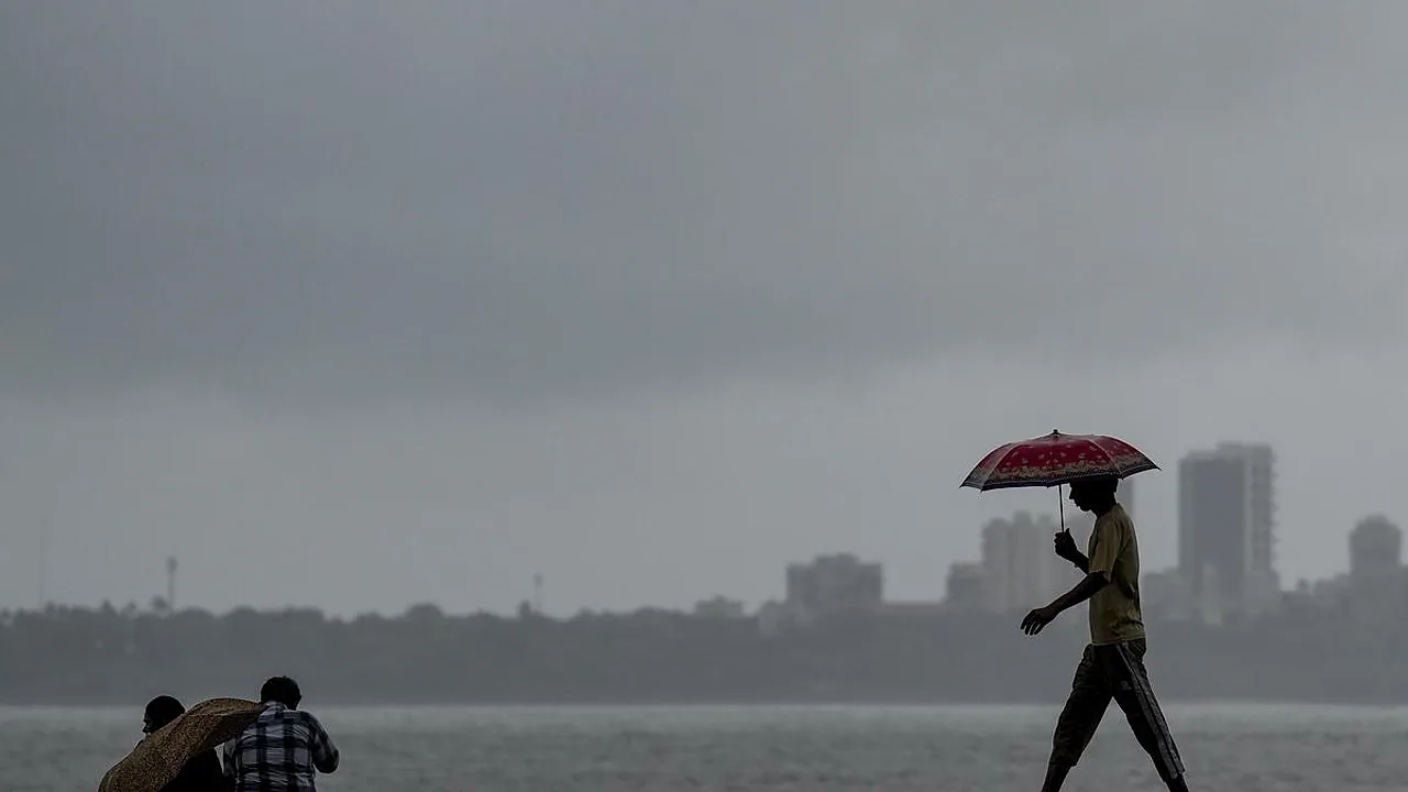
Monsoon has turned aggressive across several states, and its effects are now visible from the Himalayas to the western coast. In Uttarakhand, helicopter services for the Kedarnath Dham pilgrimage have been grounded, while parts of south Gujarat are dealing with heavy rain and waterlogging. Adding to the alert list, the weather department has issued an orange alert for Mumbai, Thane and Maharashtra's coastal belt, signalling that rainfall could intensify further in the coming days.

Kedarnath helicopter flights grounded

Helicopter services that ferry pilgrims to Kedarnath Dham have been suspended indefinitely because of bad weather. Rudraprayag District Magistrate Vishal Mishra confirmed that no flights will operate until further orders are issued. That leaves pilgrims who were relying on the air route with no fixed timeline for when services might resume.

Also read

Gujarat sees monsoon at its peak

Meanwhile, the southwest monsoon has turned active over Gujarat. Heavy rainfall has been recorded across the state's southern districts, leaving roads and low lying areas flooded in several places. The continuous downpour has disrupted daily life, and local authorities are keeping a close watch on the situation.

Orange alert for Mumbai, Thane and the Maharashtra coast

The weather department has placed Mumbai, Thane and Maharashtra's coastal districts under an orange alert. An orange alert indicates the likelihood of heavy to very heavy rainfall, a level at which both authorities and residents are expected to stay cautious. Mumbai has repeatedly seen waterlogged streets, delayed local trains and traffic snarls whenever monsoon rain intensifies, so this fresh alert has put the focus back on the city's drainage systems and traffic management.

What happens next

Taken together, the updates from Uttarakhand, Gujarat and Maharashtra show the monsoon gathering pace across western and central India. Poor weather in the hills is hitting helicopter operations, while continuous rain in the plains and coastal belt is creating waterlogging and travel disruptions. Authorities are continuing to update alerts, and further action will depend on how the weather develops in the coming days.


ENDED

Closed

  1. Monsoon pushes into south Gujarat bringing heavy rains and waterlogging; more showers forecast through July 7

    Heavy downpours swept through parts of south Gujarat on Wednesday, causing waterlogging in numerous areas as the southwest monsoon pushed further into the state, according to the India Meteorological Department (IMD). Rainfall was recorded across Surat, Navsari and Valsad districts in the southern part of the state, with showers also hitting several districts in the Saurashtra region. IMD has put out warnings of heavy to very heavy precipitation, with isolated pockets of extremely heavy rain forecast for south Gujarat through July 5. Fairly widespread to widespread shower activity is expected across multiple districts of the state through July 7. The monsoon's arrival has unleashed a sustained spell of rain over south Gujarat and the Saurashtra region, with particularly intense showers battering portions of Valsad district on Wednesday.
  2. Red alert for Palghar as relentless rains inundate Mumbai metro region

    Torrential rains pounded Thane and Palghar districts and the Mumbai Metropolitan Region (MMR) on Wednesday, triggering widespread flooding across numerous low-lying localities. Overflowing stormwater drains left residents stranded across several pockets of the region. A red alert has been declared for Palghar district, with forecasts warning of extremely heavy rainfall in the next 24 hours. The Palghar district administration has also announced a Thursday holiday for all schools and colleges in the district, officials said. Authorities noted that very heavy rains are likely to continue across Thane district for the next three days. The downpour, which began late Tuesday night, resulted in severe waterlogging across multiple residential belts throughout the region.
  3. Orange alerts sounded as southwest monsoon sweeps across most of Uttarakhand

    The India Meteorological Department (IMD) on Wednesday issued an orange alert for isolated locations in Dehradun and Bageshwar districts, flagging heavy to very heavy rainfall ahead, as the southwest monsoon pushed forward across the majority of Uttarakhand. The monsoon made its entry into most parts of the state on Tuesday, ending an extended period of oppressive humid weather and bringing widespread relief to residents. The department indicated that the remaining areas of the state are expected to come under monsoon coverage within the next one or two days. Figures from the Meteorological Centre showed Dangoli recording the highest rainfall of 98 mm over the past 24 hours, followed by Kausani (80 mm), Pithoragarh (68.3 mm), Dehradun (62 mm), Banbasa and Champawat (61 mm each), Garud (60 mm), Kalsi (50.5 mm), Jageshwar (48.5 mm) and Bageshwar (26.5 mm).
  4. Maharashtra | Powai Lake overflows in Mumbai despite delayed monsoon onset, city reservoirs remain critically low

    Heavy rain lashing Mumbai caused Powai Lake in the city's eastern suburbs to begin overflowing in the early hours of July 1, even as the seven reservoirs responsible for supplying the metropolis's drinking water remained at a worryingly low level compared to a year ago. The Brihanmumbai Municipal Corporation (BMC) announced that the overflow started at approximately 5.30 am. In a post on X, the civic authority noted that Powai Lake holds up to 545 crore litres of water and that this supply is dedicated entirely to industrial use, not drinking water. The excess water from the lake flows into the Mithi river, which eventually empties into the Arabian Sea at Mahim. Last year, Powai Lake had crossed its brim as early as June 19. The later date this year is a direct consequence of the monsoon's delayed arrival over Mumbai. When the lake is at full capacity, its water surface stretches across roughly 2.23 sq km, and its total catchment area spans 6.61 sq km. Built in 1890 at a cost of ₹40 lakh, the lake sits about 27 km from the BMC's main office. Seven reservoirs running far below last year's mark At 6 am on July 1, the collective water storage across the seven lakes that feed Mumbai's taps stood at just 7.18% of their combined capacity — a sharp drop from 41.17% recorded on July 1, 2025. Every day, Mumbai draws 3,850 million litres (385 crore litres) of water from Bhatsa, Upper Vaitarna, Middle Vaitarna, Tansa, Modak Sagar, Vihar and Tulsi lakes.
  5. Uttarakhand | SMS alerts dispatched as IMD issues three-day orange rain warning

    On July 1, the Uttarakhand government activated emergency measures in response to a three-day 'Orange Alert' declared by the India Meteorological Department (IMD) for heavy rain, dispatching SMS weather advisories to communities across high-risk and vulnerable zones throughout the state. Vinod Kumar Suman, Secretary for Disaster Management and Rehabilitation, cautioned that the ongoing Char Dham Yatra pilgrimage could see a steep fall in the number of devotees should the rains grow more intense across the Himalayan belt. Speaking to ANI, the DM stated, "The IMD has issued an 'Orange Alert' for three days... Alerts are being sent via SMS to areas where heavy rainfall is expected. The Char Dham Yatra is currently underway, but the number of pilgrims will certainly decrease if the rainfall intensifies…"
  6. Himachal Pradesh | Pre-monsoon destruction toll: 128 dead, financial damage climbs to ₹2,984.27 lakh

    Pre-monsoon rains and hostile weather have caused large-scale destruction across Himachal Pradesh, battering critical infrastructure and claiming 128 lives between March 1 and June 30. The State Emergency Operation Centre (SEOC), in its latest report issued on July 1, 2026, put the total financial toll at ₹2,984.27 lakh — roughly ₹29.84 crore. The ongoing spell of rough weather has left 44 roads impassable across the state, throwing transportation into serious disarray. The Public Works Department (PWD) said Mandi district has borne the brunt with 28 road closures, while Shimla accounts for 17 blocked routes. The Revenue Department's Disaster Management Cell separately confirmed that 128 people lost their lives to weather-driven incidents over the four-month pre-monsoon period.
  7. Uttarakhand | Kedarnath Dham Yatra: Helicopter ops halted, pilgrims to depend on ponies, mules and palanquins

    Helicopter operations serving the Kedarnath Dham Yatra have been brought to a halt as the monsoon season sets in, with adverse weather and passenger safety cited as the driving reasons, officials announced on July 1, 2026. The move has been made in compliance with directives from the Directorate General of Civil Aviation (DGCA), authorities confirmed. Rudraprayag District Magistrate Vishal Mishra stated that all helicopter services connected to the pilgrimage stand suspended until further orders. "Thambi Aviation, Himalayan Heli, Rajas Aero, United Helicharters, Pilgrimage Aviation, Chipsan Aviation, Trans Bharat Aviation and all other operators have dispatched their aircraft back to their respective home bases following the suspension. During the monsoon period, pilgrims will need to make use of alternate means of travel such as ponies, mules and palanquins. A resumption of helicopter services will only take place once weather conditions improve and the necessary clearances are granted," he said.
  8. Southwest Monsoon spreads across Himachal Pradesh after six-day delay

    The Southwest Monsoon officially advanced over all of Himachal Pradesh on July 1, 2026. This marks the full coverage of the hill state, six days past the typical onset date of June 25. According to the India Meteorological Department (IMD), the monsoon moved into the remaining pockets of the state on July 1, bringing every region under its sweep. In this final phase, the monsoon reached the leftover areas of Shimla district, including Shimla city, as well as Sirmaur, Mandi, Kullu, Lahaul and Spiti, and Kangra. It also enveloped the entirety of Solan, Una, Bilaspur, Hamirpur, and Chamba districts. The IMD had previously predicted that conditions were highly favorable for the monsoon's progression into the remaining areas of Himachal Pradesh over a two-to-three-day window. With the entire state now covered, widespread rainfall is anticipated throughout the upcoming week. The meteorological department has forecast widespread precipitation across Himachal Pradesh, warning of heavy to very heavy downpours at isolated locations over the next few days. Additionally, a new Western Disturbance is projected to impact northwest India starting July 2, which could further intensify the rain across the state.
  9. Uttarakhand: Administration closely monitors Kedarnath Yatra route amid rain alert

    Following alerts from the meteorological department, the district administration of Rudraprayag has been placed on high alert. With the onset of the monsoon season, the district has been issued Yellow and Orange alerts for various time frames. Intense rainfall is currently continuing in multiple locations across the district, including the shrine area of Kedarnath. In response to the current weather patterns, the district authorities along with the Disaster Management Department are keeping a close watch on the situation via their control room. They are maintaining a continuous vigil over the national highways, the Kedarnath Yatra route, and other high-risk zones. All relevant departments and administrative officers have been instructed to remain highly vigilant to ensure the safety of both local residents and pilgrims. Earlier today, the IMD in Dehradun predicted heavy rainfall for the next four days (until July 4) in Uttarakhand's Rudraprayag district. This prompted local authorities to call for extreme vigilance from the public. Owing to the weather forecast, the administration has urged individuals to stay away from rivers, fast-flowing streams, and regions prone to landslides as a safety measure. Officials have requested the public to show caution and adhere to the guidelines issued by the administration to stay safe during this period of expected heavy precipitation. The local administration stated that it is constantly tracking the developments and advised people to keep themselves informed through official weather updates and alerts.
  10. Himachal Pradesh: Several rivers overflow, roads blocked after heavy rainfall

    The water levels in multiple rivers and their tributaries across Himachal Pradesh witnessed a rise on July 1, 2026. The Swan river in Una district was flowing with high volume and speed, leading authorities to warn residents against going near the riverbanks. According to data from the State Emergency Response Operation Centre, a total of 28 roads were blocked in Mandi, 12 in Kullu, and two roads each in Lahaul and Spiti and Una districts. Heavy downpours have been recorded across several parts of the state since Tuesday evening. Nagrota Suriyan in Kangra district logged the maximum rainfall of 102.5 mm. Other areas also recorded significant rainfall: Ghamroor (95.2 mm), Guler (87.2 mm), Palampur (74.4 mm), Saloni (68.2 mm), Jogindarnagar (48 mm), Kahu (44.5 mm), Dehra Gopipur (38.3 mm), Berthin (37.4 mm), and Sujanpur Tira (36 mm), as per official figures. Rain also lashed popular tourist destinations such as Shimla, Manali, and Dharamshala. Thunderstorms accompanied by lightning were reported in Kufri, Palampur, Kangra, Sundernagar, Jubberhatti, and Bhuntar.
  11. Heavy Downpours Batter Himachal, Roads Shut and Rivers in Spate

    Severe rainfall battered multiple areas of Himachal Pradesh on Wednesday (July 1, 2026), with Shimla, Manali and Dharamshala among the hardest-hit towns. Officials reported that roads across several districts were blocked, river levels climbed sharply and electricity services were knocked out. Schools — both government and private — that had remained closed owing to the summer heat welcomed students back, though attendance was thin as the relentless downpour kept most pupils at home. With the southwest monsoon now firmly entrenched over the hill state, there is little prospect of any let-up. The regional meteorological office has put out an orange alert flagging heavy to very heavy showers at scattered locations from July 2 through July 6, with July 4 as the sole exception.
  12. Indian Ocean Dipole Explained: The Ocean Phenomenon That Can Shield India's Monsoon

    During the monsoon season of 1997, the Central Pacific was in the grip of one of the most ferocious El Niño events ever recorded. By every established rule of meteorology, India should have been staring down one of its most severe droughts. Yet the opposite unfolded — the June-through-September monsoon delivered surplus rainfall, finishing roughly 2% above the normal mark. Mrutyunjay Mohapatra, Director-General of the India Meteorological Department (IMD), has observed that this outcome has "happened only once ever." The hidden engine behind that improbable escape lay not in the Pacific but in India's own neighbouring ocean — a phenomenon called the Indian Ocean Dipole (IOD). This explainer examines how the IOD shapes India's monsoon, set against the backdrop of a forecast 'Super El Niño,' and charts the historical significance of this remarkable oceanic pattern.
  13. Heavy Mumbai rains spark massive traffic gridlock on Western Express Highway

    Intense rainfall lashing Mumbai triggered a severe traffic bottleneck on the Western Express Highway near Santacruz East, with vehicles backed up in long queues as the heavy downpour persisted.
  14. Thick clouds descend over Mandi town as orange alert comes into force for two days

    With an orange alert declared for July 2 and 3, thick clouds have moved in over Mandi town, signalling a notable shift in weather conditions. The Beas River is currently flowing at its normal level, and no unusual surge in water or any indication of flooding has been observed so far.
  15. Orange alert activated for Mumbai, Thane and coastal Maharashtra as IMD forecasts heavy downpours

    The India Meteorological Department (IMD) has put a three-hour Orange alert in place covering Mumbai, Thane, Palghar, Raigad, Ratnagiri and Sindhudurg, effective from 10:15 a.m. IST on July 1, 2026. The department anticipates moderate to heavy rain bursts at scattered locations across these six districts. Residents of the affected areas have been advised to stay cautious, as rough weather conditions are expected to persist through the alert window.
  16. Waterlogging surfaces in Mumbai's Wadala after heavy rainfall

    Incessant heavy rainfall triggered waterlogging conditions across the streets of Mumbai's Wadala neighbourhood.
  17. Delhi forecast for overcast skies and moderate showers; yellow alert issued for strong afternoon winds

    Delhi's minimum temperature on Wednesday stood at 28.6℃, with IMD predicting a day of predominantly overcast skies and moderate rainfall. The department additionally sounded a yellow alert flagging strong surface-level winds expected to blow through the afternoon and evening. Weather data recorded minimum readings of 26℃ at Palam, 28℃ at Lodhi Road, 24.5℃ at the Ridge and 27.4℃ at Ayanagar — none of these figures straying more than one degree from the typical seasonal norm. -PTI

Comments 0

No comments yet — be the first.

Citizen journalism

Become a TrendKia journalist

Voice of the people

Share news, photos and videos from your area with TrendKia and let your voice reach the nation. Every citizen a journalist.

Join now
CH 01 LIVE
TrendKia TV ON AIR