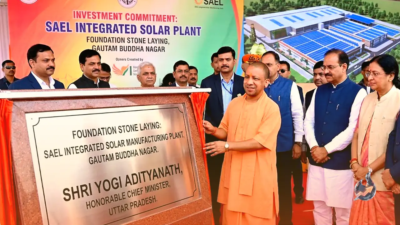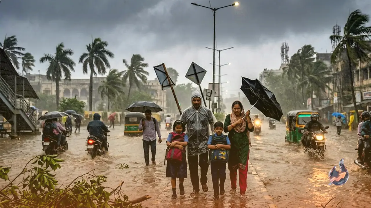

The heatwave and intense humidity that dominated the end of June are rapidly giving way to a dramatic meteorological shift across India as July begins. The Southwest Monsoon, which initially progressed at a sluggish pace, has suddenly gained massive momentum. The India Meteorological Department (IMD) has issued critical weather alerts for twenty-three states, warning of heavy downpours, severe thunderstorms, lightning strikes, and gale-force winds reaching speeds of up to 75 kilometers per hour. A combination of multiple powerful atmospheric systems is converging simultaneously over different parts of the country, setting the stage for a highly volatile and significant weather phase over the next four to five days.
The Convergence of Four Major Atmospheric Systems
The sudden acceleration of the monsoon is being driven by the unique and simultaneous activation of four distinct weather phenomena. Firstly, a new low-pressure area is currently taking shape over the North Bay of Bengal and adjoining southern Bangladesh, which is expected to inject massive amounts of moisture into the eastern and central regions of the country. Secondly, a highly active cyclonic circulation has established itself over eastern Bihar, creating strong instability in the regional atmosphere. Thirdly, an off-shore trough is stretching along the western coast from Maharashtra all the way to Kerala, which is bound to trigger heavy to very heavy precipitation along the coastal belt. Lastly, starting July 2, a fresh Western Disturbance is scheduled to move over Northwest India, interacting with the easterly monsoon winds and intensifying weather activity across the northern plains and Himalayan regions. In addition to these systems, a mid-tropospheric trough is extending from Madhya Pradesh down to the Arabian Sea, ensuring that central India receives a substantial share of the wet spell.
Rapid Progression of the Southwest Monsoon
While the initial journey of the Southwest Monsoon was slow and uneven, its advancement has now entered a highly active phase. According to official meteorological data, the monsoon has successfully covered the remaining parts of Madhya Pradesh, Chhattisgarh, Bihar, and Jharkhand, and has made deep inroads into several parts of Uttar Pradesh. Over the next forty-eight to seventy-two hours, the monsoon is highly likely to advance further, covering Delhi, Haryana, Punjab, Rajasthan, Jammu and Kashmir, and extensive areas of Himachal Pradesh. Forecasters anticipate that the low-pressure system forming in the first week of July will act as a primary engine, dragging heavy rain clouds into the central and northwestern parts of India, although this will also bring an increased risk of lightning strikes and strong gusty winds.
Severe Storms and Relief from Heat in Delhi-NCR
The national capital and its surrounding regions are poised for a dramatic weather transition as July commences. On July 1, Delhi-NCR is expected to experience widespread heavy rain accompanied by violent thunderstorms and winds gusting between 60 to 70 kilometers per hour, with some localized areas witnessing even stronger gales. The maximum temperature is projected to drop to around 31 degrees Celsius, while the minimum temperature will hover near 28 degrees Celsius, offering much-needed relief to residents who have been battling extreme heat and suffocating humidity. However, authorities warn that these high-speed winds and intense downpours bring a high probability of uprooted trees, significant waterlogging in low-lying urban areas, and major disruptions to vehicular traffic.
Extensive Orange and Yellow Alerts Across Uttar Pradesh
The monsoon’s grip over Uttar Pradesh is tightening rapidly, with heavy rain and destructive winds on the horizon. The meteorological department has highlighted a high-risk zone covering a vast number of districts including Agra, Mathura, Kanpur, Jhansi, Banda, Gonda, Bahraich, Siddharthnagar, Gorakhpur, Varanasi, Mirzapur, Prayagraj, Ballia, Azamgarh, Mau, and Chandauli, along with neighboring territories. These regions are on high alert for intense rain and powerful squalls blowing at speeds of 70 to 75 kilometers per hour. Frequent lightning strikes also pose a significant hazard to life and property. In the capital city of Lucknow, the maximum temperature is expected to settle around 33 degrees Celsius, with the minimum dropping to 28 degrees Celsius. While eastern and central Uttar Pradesh are predicted to bear the brunt of the heaviest rainfall, western parts of the state will also undergo a rapid and noticeable transition.
Flood Threats and Agricultural Impact in Bihar
In Bihar, the active cyclonic circulation situated over the eastern portion of the state is set to trigger widespread and heavy precipitation. Heavy rainfall warnings have been issued for a multitude of districts, including West Champaran, East Champaran, Gopalganj, Siwan, Saran, Vaishali, Muzaffarpur, Samastipur, Darbhanga, Madhubani, Purnia, Kishanganj, Katihar, Bhagalpur, Khagaria, and Araria. These areas are also expected to experience strong winds ranging from 60 to 65 kilometers per hour. In the state capital, Patna, temperatures are predicted to range between a maximum of 34 degrees Celsius and a minimum of 28 degrees Celsius. While the continuous rainfall is highly beneficial for the agricultural sector, particularly for paddy sowing, the high-speed winds pose a severe threat of lodging and damaging standing crops. Furthermore, prolonged heavy spells could lead to localized flooding and waterlogging in low-lying residential sectors.
Monsoon Fury in Jharkhand and Wet Spell in West Bengal
The neighboring states of Jharkhand and West Bengal are also bracing for intense weather conditions. In Jharkhand, the monsoon has established a strong and active presence. Moderate to heavy rainfall is expected across several districts, including Sahebganj, Pakur, Ranchi, Khunti, Devghar, Dhanbad, Jamshedpur, Gumla, Latehar, Ramgarh, Garhwa, West Singhbhum, and East Singhbhum. Ranchi is likely to record a maximum temperature of 29 degrees Celsius and a minimum of 24 degrees Celsius. The persistent downpours are expected to cause a significant rise in the water levels of regional rivers, reservoirs, and dams, prompting local administrations to monitor the situation closely.
Meanwhile, in West Bengal, the developing low-pressure system in the North Bay of Bengal will significantly amplify rainfall activities. Extensive regions, particularly Purulia, Bankura, Nadia, Murshidabad, West Medinipur, East Bardhaman, North 24 Parganas, and Jhargram, are expected to receive heavy rainfall accompanied by strong, gusty winds blowing at speeds of 60 to 70 kilometers per hour, presenting challenges for local commuters and infrastructure.